Peirce Island WWTF Resiliency

Project Update: June 4, 2024:
- Completed raising the road and parking area
- Completed installation of the permeable grass paver driveway


In September 2023, the City of Portsmouth was notified that it had received $965,333 in Congressionally Directed Spending (CDS) from the Federal Pre-Disaster Mitigation (PDM) Grant Program through the NH Department of Homeland Security and Emergency Management for the Peirce Island Road Resiliency Project. Work on the project is scheduled to start the week of April 15, 2024 and is anticipated to be completed in mid-June 2024.
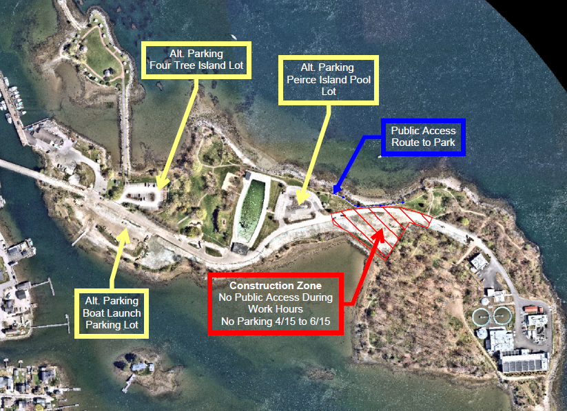
The project will raise a 400-foot-long section of Peirce Island Road and the adjacent parking area to three feet above the current 100-year floodplain. Additionally, a portion of the packed gravel parking area will be replaced with grass pavers and vegetation to improve stormwater management. The road portion of the project is scheduled to be completed first with the lot portion following, in an effort to minimize traffic impacts to the Pierce Island WWTF. Flaggers will be in place, as necessary to manage traffic flow. No parking will be allowed within the construction zone (see map) for the duration of the project from April 15, 2024 to June 15, 2024. In addition, the Peirce Island Off Leash Dog Park will be restricted to on-leash use during construction hours Monday through Friday 7 am to 4:30 pm. The only access to the park during construction hours will be via the existing trail along the north side of the road (see map). Off-leash use of the park will resume at the end of each workday and the site will be left in such a manner to allow safe public access. A message board detailing park restrictions and parking ban duration is located immediately before the construction zone.
The City applied for the grant to provide consistent access to the Pierce Island Wastewater Treatment Facility (WWTF), a critical municipal service. Pierce Island Road, the sole access road to the critical infrastructure facility, currently floods during spring high tides and storm events. Raising the road approximately 3 feet above its current lowest point will elevate it above the 100-year flood line and protect it against predicted sea level rise. The raised road will also offer greater protection to the force mains under the road that carry wastewater to the WWTF.
No impacts to the rocky shore, salt marsh or marsh elder are anticipated and the City will comply with the conditions set forth in the NH Department of Environmental Services (NH DES) Wetlands Permit to minimize any potential impacts to nearby wetlands. Once completed, the project will maintain the existing walking trail and vegetation north of the road supplementing the existing site with a narrow buffer of stone and upland plantings between the trail and the road to protect the road from high water and wave action during storms. The existing gravel lot will be raised and replaced with a more permeable reinforced turf parking area and a grass paver driveway. These surfaces decrease runoff by promoting absorption of stormwater.